MarsSI
Version 5.1 - Sept 2016
by Loïc Lozac’h https://emars.univ-lyon1.fr/
![]()
What is MarsSI?
MarsSI (Acronym of MARS Information System) is a web Geographic Information System application which allows the managing and processing of Martian orbital data.
From this application, the user is able to easily and rapidly select observations, to process raw data via proposed automatic pipelines and to get back final products which can be visualized under GIS application like ARCGIS and QGIS. Moreover MarsSI also proposes an automatic stereo-restitution pipeline in order to produce Digital Terrain Models (DTM).
How to use MarsSI?
MarsSI’s interface is built on Geomajas, an open source web GIS application framework. It shows MOLA or THEMIS global maps of Mars and ground footprints of martian missions remote-sensing instruments.
")
In order to obtain a map-projected raster file, user only needs to select and add footprints into his cart and launch the dedicated process with just one button. Processed data can be accessed via ftp.
Documentation and video tutorials are available at this adress
Which data is available in MarsSI?
Data available in MarsSI comes from the last 3 orbiters around Mars. Data is downloaded from the NASA Planetary Data Server (PDS) and processed with several software like USGS ISIS3, ENVI IDL, AMES Stereo Pipeline…
Mission , instruments and highest level of processing
- Mars Reconnaisance Orbiter (MRO)
- CTX: Map-projected calibrated raster and Stereo-restitute DTM
- HiRISE: Map-projected calibrated raster and Stereo-restitute DTM
- CRISM: Map-projected calibrated raster with spectral parameters
- Mars Explorer (MEX)
- HRSC: Map-projected calibrated raster and Stereo-restitute DTM created by HRSC team
- OMEGA: PDS Raw data
- Mars Odyssey (ODY)
- THEMIS: PDS Raw data
Stereo-restitution
The stereo-restitution pipeline is functional for HiRISE and CTX images. CTX and HiRISE possible DTM footprints are computed, according to the following constraints: image couples with 60% width-overlapping and a minimum deviation of 5° in emission angle. It is user’s responsibility to check the quality of the stereo pairs, thanks to their PDS on-line label files. Then, the user can choose one or several stereo footprints from the map view and they appear in the stereo-restitution view. If the raw image couple is not stored on the local server, MarsSI automatically adds the 2 images to the user’s cart and ask him to process the data before launching the stereo-restitution application. The script pipeline uses the Ames Stereo Pipeline toolkit to process the stereo images and automatically obtain DTM.
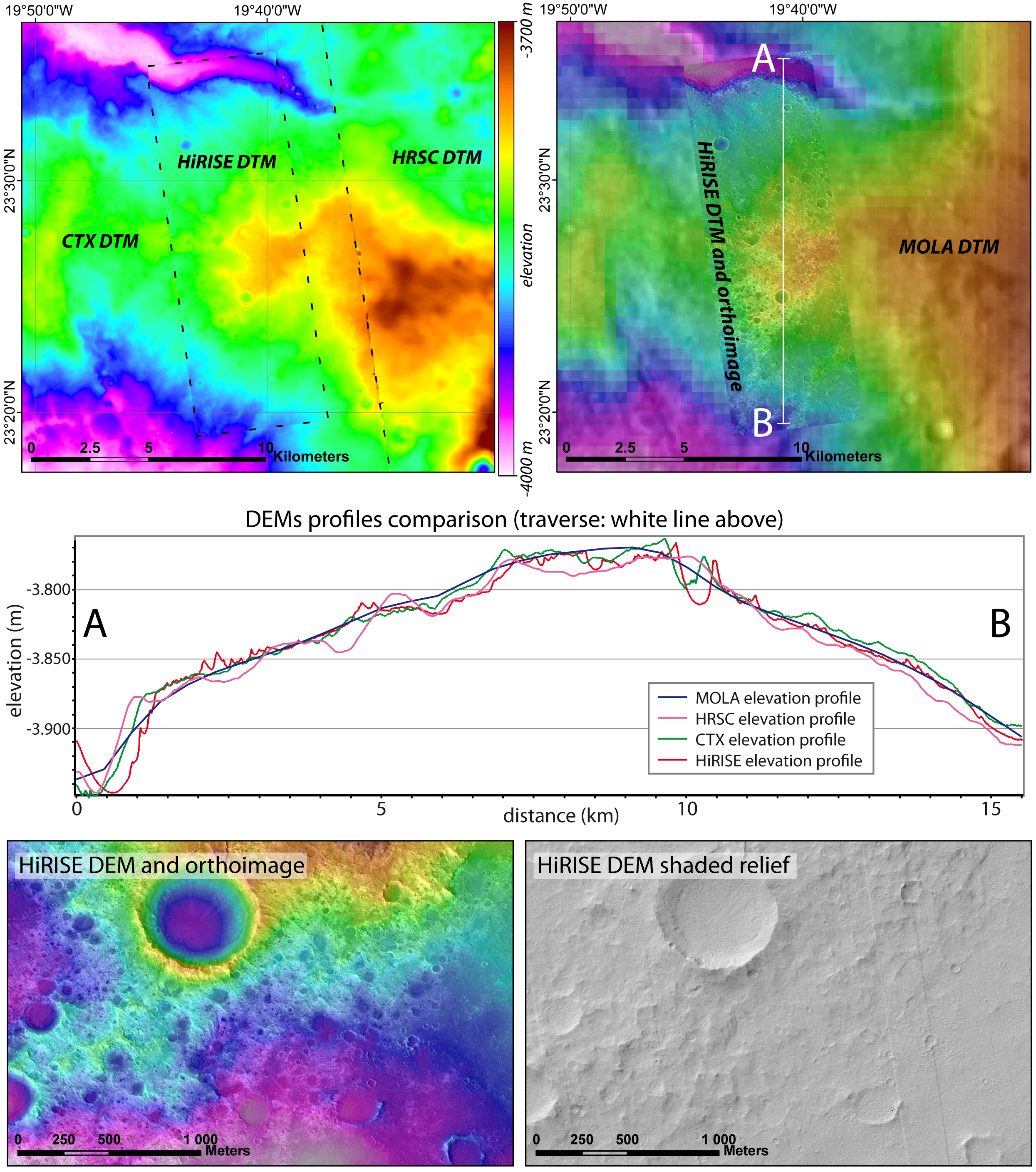
Above figure shows examples of DEMs generated by MarsSI and compared with lower resolution DEMs. The top images show the same area (inside Oyama crater) with DEMs from HiRISE, superposed on CTX, superposed on HRSC on the left, and on the right the same HiRISE DEM with transparency on its associated orthoimage, superposed on the MOLA DEM with transparency on the THEMIS IR daytime mosaic. The north-south line indicates the location of the elevation profiles. The bottom images show close-ups on the HiRISE DEM and its associated orthoimage, and a shaded relief from the same DEM.(HRSC DEM from the HRSC MC-11 (East) DEM mosaic, CTX DEM from orbits 007388 and 024912, HiRISE DEM and orthoimage from orbits 037505 and 037993).
The limits between the different DEMs are still slightly visible due to differences in resolution that lead to high resolution elevation differences pixel to pixel, to edge effects, and to slight horizontal shifts between datasets. However the high-resolution DEMs fit in very well inside the low resolution one.
Credits
This application is part of the ERC project e-Mars founding from the European Union’s Seventh Framework Program (FP7/2007-2013) (ERC Grant Agreement No. 280168). By using MarsSI, you agree to acknowledge the use of this application while publishing results. The acknowledgement sentence has to be as follow: “Data have been processed with the MarsSI (emars.univ-lyon1.fr) application founded by the European Union’s Seventh Framework Program (FP7/2007-2013) (ERC Grant Agreement No. 280168)”.