We’re happy to announce the kick-off of OpenPlanetaryMap (OPM), a collaborative effort from within the OpenPlanetary community and based on “Where On Mars?” to build the first Open Planetary Mapping and Social platform.
We are a small interdisciplinary and international team of researchers, developers and designers passionate about planetary mapping and cartography. We started to form our team in January 2017 and held a first meeting in Berlin two months later to kick-off the project.
The OpenPlanetaryMap project is supported and made possible thank to our partner CARTO, through their Grant Program. That also means that we’re adding a new piece to our common OpenPlanetary Framework, a multi-user cloud-based geospatial data visualisation and analysis platform!
Vision
Our long-term vision is to enable a community of planetary scientists, space enthusiasts, educators and storytellers to easily and collaboratively create and share location-based knowledge and maps of planets in our Solar System.
Think of it as an hybrid between OpenStreetMap and Google Maps for planets.
Objectives
We aim to launch a first version of the OpenPlanetaryMap platform at the next European Planetary Science Conference in September 2017.
-
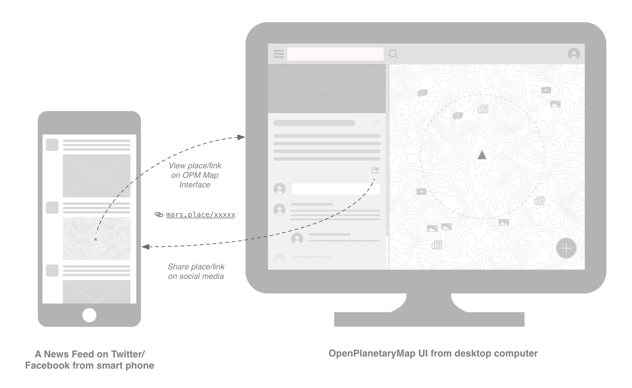
Web Map Interface : As part of this platform, we will develop a web map interface that will make it easy and enjoyable for novice people to discover, search, share, discuss and add their own Places on Mars (we will expand to other planets in a second stage). We aim to provide a social experience that will help creating an emotional connection with Mars and incentives to learn and share knowledge about it.
-
Open Datasets Repository: A key element of the platform will be an open datasets repository containing a curated selection of location-based information and places of interest about Martian geography, topography, geology, weather, climate, scientific missions and discoveries, robotic and human exploration. These scientifically accurate data sets, along with public crowdsourced datasets, will be programmatically accessible and reusable by others to develop third-party applications for specific scientific or outreach purposes.
-
Basemap: We will also design and implement at least one beautifully crafted vector-based basemap of Mars that will serve as the base layer of our web map interface and enrich its overall user experience. It will be made publicly available to foster the creation by others of theme-based maps of Mars that can be easily shared on the web and social media.
Initial concepts
Initially, the Places on Mars the audience will learn about will include information from curated datasets, as well as from a public crowdsourced dataset of Places. These Places will either be related to a physical object or phenomenon (i.e.: crater, dune, gully, dust devil, cloud), or to a more abstract one that contributes to increasing knowledge of Mars (i.e.: scientific publication, blog article, Wikipedia page, tweet, panoramic image, video, question, story, event). Our audience will also learn from discussions they have with each other, including with planetary scientists.
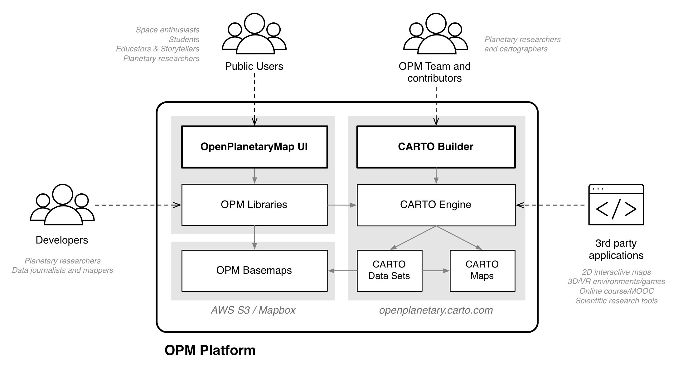
The OPM platform will almost entirely rely on the CARTO Engine and Builder. The following diagram illustrates how CARTO will fit into the OPM platform, and what users and applications interact with it:
Expected outcome and impact
We aim to make novice people feel that Mars is at their reach, both in terms of knowledge and preconceived physical proximity. We want them to use our future web application to quickly and regularly learn something about Mars, just like people head to Google Maps to find their bearings or any location-based information.
With an Open Data and Open Science philosophy in mind, we aim to encourage planetary scientists and mappers to share and collaborate on research data sets in a way that is beneficial to all parties: peers, graduate students, science communicators and the general public.
We aim to encourage science communicators, educators and storytellers to contextualise more their publications or resources by providing better location information, so as to allow their audience for further exploration and better understanding of a related topic or story.
Being an open source project, we also hope to encourage a younger audience of STEM students to apply or acquire new skills in cartography, Geographical Information System (GIS), and programming, by contributing to the OPM software and platform development.
Help us build something that you want!
Throughout the project, we will adopt an iterative development approach and try to follow a user-centered design process as much as possible. We will organize co-located hackathons at planetary data workshops and other events, to learn from potential users and experts, and stay in line with our objectives.
Being collaborative by nature, we will encourage everyone who is interested in this project to contribute with their expertise: in planetary cartography, web development, geospatial data processing, communicating science or any other areas that we haven’t yet thought of.
How you can contribute?
At this early stage:
- You can subscribe to our Newsletter.
- You can follow us on Twitter.
- You can watch us on GitHub.
- You can comment this post
- You can get in touch and chat with us on Slack.

Thanks for reading and stay tuned! — The OPM Team: Nicolas, Andrea, Myles, Stephan, Angelo, Trent, John and Henrik.